-
City Services
-
- Departments Administration Building City Recorder Community Development Community Emergency Response Team Finance Floodplain Management Human Resources Parks & Recreation Public Works Police Urban Renewal Utility Billing
- Commissions and Committees Arts Commission Budget Committee Citizen Advisory Committee Parks Foundation Parks and Recreation Commission Planning Commission
-
Agendas and Minutes
City Council
-
-
Community
-
- Schools Crater High Scenic Middle Central Point Elementary Mae Richardson Elementary Jewett Elementary School District 6 Map Rogue Community College Southern Oregon University
- Special Events Calendar of Events Park Special Events Recreation City Activity Guide City Parks British Soccer Camp Jackson County Expo Bear Creek Greenway Bike Path Rogue River Greenway Bike Path Hiking Paths Made in Southern Oregon
- New to Central Point Chamber of Commerce Central Point Library Justice Court Utility Services Senior Center Post Office Airport Get Involved Commissions & Committees Volunteer Parks Foundation Elections
-
-
Resources
-
- Online Resources Pay Your Water Bill Pay a Ticket Online Job Opportunities Municipal Code Documents and Reports Forms and Applications City Documents Library Portal Water Usage Portal COVID-19 Updates Alerts and Notifications Email Subscriptions Maps
- Events and Meetings Agendas and Minutes Ordinances Resolutions Calendar Local Services Jackson County City of Medford Justice Court Recycling
- Connect Submit a Request or Concern Staff Directory Facebook Twitter In the News City News City Newsletters
-
-
Business
-
- Start a Business Business Licenses Chamber of Commerce Building/Construction Building Permits Inspection Requests Design Criteria Building Forms Bids and RFPs Forms and Permits
- Community Development City Projects Zoning & Land Development Code Long Range Planning Maps
- Urban Renewal Urban Renewal Home
-
-
Public Safety
-
- Communications Mission & Core Values Organizational Chart What We Do Patrol School Resource Officers (SRO) Community Service Officers Police Support Specialists Police Volunteers
- Get Involved Join the Team Becoming a Volunteer Neighborhood Watch Community Emergency Response Team Requests Police Reports and Records Check
- Resources Municipal Code Traffic Safety Police Events/Calendar Court Information Vehicle Impound Release Frequently Asked Questions
-
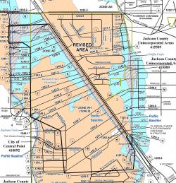
Effective September 14, 2016, flood zones within the Twin Creeks Development have changed. Changes includes reductions to the floodplain and floodway boundary width, as well base flood elevations throughout the area. If you are a homeowner residing in Twin Creeks, you may contact the City for a revised flood zone determination. This is important because flood insurance requirements and rates are based on whether or not a structure is located within a high risk flood hazard area, how deep the expected flood waters will be and several other factors related to construction.
Provided below is a list of resources for homeowners, insurance agents and surveyors:
- Letter of Map Revision. Click here to download the effective Letter of Map Revision (LOMR). You will likely need this documentation for purchasing a home and obtaining a new or revised flood insurance policy.
- Flood Risk Determination. To obtain updated flood risk information from the revised map, please contact the City at (541) 664-3321, Ext. 243 or 244.
- Elevation Certificate or Letter of Map Amendment (LOMA). To revise an existing flood Elevation Certificate or explore your eligibility for a Letter of Map Amendment (LOMA), contact a licensed land surveyor in our area.
- Flood Insurance. To determine your options regarding flood insurance, please contact your insurance agent.

